 |
 |
|||
along The |
||
The daywas cool and cloudy, as the wethaerpeople had forecast; My friend, Bruce, drove up from Annapolis to pick me up in Odenton, then we drove to White Hall, in northern Baltimore County. & There we parked acrosss from the Ivory Mill to access the trail (the official name of which, in Maryland, is the Torrey C. Brown Rail Trail).
The trail runs 20 miles from Cockeysville, Maryland to the Mason-Dixon Line (the border between Pennsylvania and Maryland), where it becomes the York County Heritage Trail, which continues just over 21 miles to York, Pennsylvania. Today we would cover the 9 miles from White Hall to the state line, then an additional 1 mile to New Freedom.
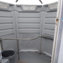 The trail has porta-potties here and there, but they're spaced about every four miles. However, what they lack in convenience of
location they more than make up for in spaitial splendor: these tings aren't porta-pottys, they're porta-palaces
- they're wheelchair-accessible, almost round (not square like the normal spot-a-pot), and they're about eight feet in diameter,
with handicap railings inside!
The trail has porta-potties here and there, but they're spaced about every four miles. However, what they lack in convenience of
location they more than make up for in spaitial splendor: these tings aren't porta-pottys, they're porta-palaces
- they're wheelchair-accessible, almost round (not square like the normal spot-a-pot), and they're about eight feet in diameter,
with handicap railings inside!

About half a mile from White Hall we happened upon "Gnome Hill", a rock dome covered with- yes, you guessed it - gnomes. The hill is topped by a flagpole with both the United States flag and the Maryland state flag, but it is populated, in every possible crevice and on every possible ledge, by gnomes of all descriptions. The "hill" is also interspersed with fountains (the things covered by green bags in the photo). The hill is owned by an affiable gentleman who, during warmer weather, sells refreshements to the denizens of the trail.
As we pedalled along, we saw evidence of horses using the trail (and -ahem - "using" the trail); fortunately, most of the time the "land mines, as Bruce called them, were off to one side. There was one horse, however, who was so rude as to do its business right down the middle of the trail (well, I guess that was polite - at least it wasn't down the middle of one of the paths!). That's not to say that there weren't "land mines" in the middle of the paths; fortunately they were ancient and had dried out by the time we happened upon them. (Sorry, no pictures of the "land mines"; this is a family-friendly web page).
There are remains of several old railroad bridges and trestles along the trail - the bridges are concrete or steel plate girder, and
the trestles are - well, wood. Every mile or so there are whistle posts, and granite markers with mileages emblazoned on them.
We couldn't figure out the destinations for the mileposts - the numbers were, for example, 133/33 (that is,133 on one side
and 33 on the other). The best we could figure was the lower numbers were the miles to Baltimore and the upper numbers the miles to
Salisbury (the Pennsylvania terminus of the Northern Central). The higher numbers were viewed as we rode north on the trail, toward
Pennsylvania. 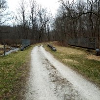
|
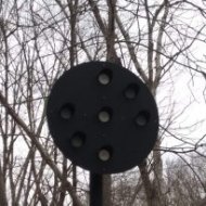
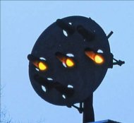
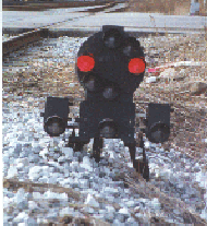
RAILFAN ALERT! Railroad signal information follows Also along the Maryland section of the path was a replica of a Pennsylvania Railraod position-light signal. It was a respectable replica (there was a real one in New Freedom). The PRR's position-light signals used amber lamps displayed in rows of three in either vertical, diagonal, or horizontal orientations to indicate clear, caution, or stop, respectively; the replica signal used aluminum discs to imitate the signal's lenses. They even had the three vertical "lenses" painted white and the rest painted light gray so it appeared that the people on the path had a clear signal! One thing about the replca signal was the lens hoods were too short; the PRR signal lens hoods were long to protect the signal from snow blocking the lenses, this obscuring the signal indication. The Baltimore and Ohio didn't have the problem with snow obscuring the signal indications, since the B&O used color-position light sigals, where, while the lights were still displayed vertically, diagonally, or horizontal ly,they used colors in addition to position (hence the name). The vertical aspect, or indication, showed green, the diagonal aspect showed amber (or yellow), and the horizontal aspect showed red; if one lamp burned out or if snow covered one lamp, the other lamp would still show the proper color, thus indicating the signal's aspect. At left, top to bottom: Replica signal along Northern Central trail; Pennsylvania Railroad position light signal, and Baltimore and Ohio Railroad dwarf color-position light signal (called a "dwarf" sigbal because it's mounted near the ground rather than on a mast like the other two). End of railroad signal information |
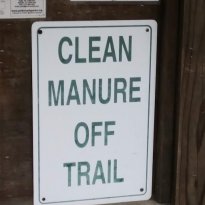 When we hit the Maryland - Pennsylvania border (the Mason-Dixon Line) there was a community bulletin board beside the trail. As we
were merely visitors, we didn't look too closely at the community notices - but we did notice a large green and white sign
(obviously not meant for us. Well, at least Pennsylvania didn't want "land mines" along the trail...
When we hit the Maryland - Pennsylvania border (the Mason-Dixon Line) there was a community bulletin board beside the trail. As we
were merely visitors, we didn't look too closely at the community notices - but we did notice a large green and white sign
(obviously not meant for us. Well, at least Pennsylvania didn't want "land mines" along the trail...
As we entered New Freedom we saw a Pennsylvania Railroad GP9, number 7580 (whether that's the real road number, or a number made up by Steam Into History, who own it, I don't know). It was attached to a series of wood coaches the steam excursion road uses for its historic train recreations. We didn't see the replica 1860s steam locomotive.
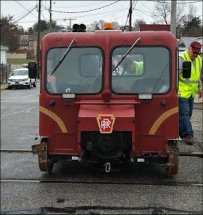
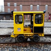
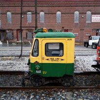
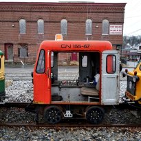
We did, however, see these little buggers...er, speeders:
|
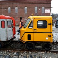
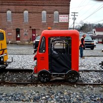
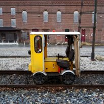
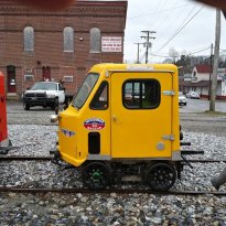
We chatted with the owner of one of the cars; he said that the group goes all over the country to small railroads that usually run freight only. Expecting to hear a five-figure number, I asked how much a speeder costs; surprisingly, I was told that an average speeder costs $5,000 to $7,000 dollars, while they can run up to the $30,000 range. I was genuinely shocked; I had expected to hear that an average speeder started around $30,000! If you'll notice one ting about the speeders, that is that they have the same wheelbases but the length of the cabs are different, and none of them have much overhang, if any (you can tell this by the proximity of the sides to the wheels). Oh yes...speeders were used by track gangs and track inspectors when they wanted to get around quickly; the gentleman with whom we spoke said he has had his speeder up to 40 MPH. That's pretty fast for a dinky contraption like a speeder!
After chatting with the speeder owner and taking these photographs, Bruce and I went to lunch (the whole purpose of our ten-mile ride) at Seven Sports Bar and Grille a block from the trai on Framklin Street (head East). Bruce had a ham and swiss (I think - well, it was some kind of cheese, anyway) and I had fish and chips. Man, oh man! If you are ever in New Freedom, you have got to go to Seven and get the fish and chips!!
Did I mention that once we got near New Freedom it started to spit off and on? Well, it did - and once we got downtown it was raining steadily. The speeder owners were standing around under unbrellas and Bruce and I were standing there in our bike helmets. Well, at leas I had on jeans; poor Bruce only had on biking shorts. After about 45 minutes in Seven it was time to leave. We got on our bikes and headed back South toward White Hall, ten miles, in the rain. It was a 2% grade all the way uphill from White Hall to New Freedom, but it was 2% all the way downhiil on the way home, I got to see some speeders and a G9, and I had a good lunch and good company. Rain notwithstanding, it was a great day.
I tried to convince my wife that she wanted to go on the trail, but when I told her it was 2% uphill for 10 miles she said "uh-uh!". I don't undstand...
 |
|
|
|
|
| Home | |
| Photos of Orangeville engine terminal, Baltimore, in the summer of 1983 | |
| more Orangeville pics | |
| Orangeville maps, plus construction history | |
| Photos of Orangeville when it was active | |
| Camden Yards (railroad, not baseball) page | |
| Mike's Railroad Page | |
 |
A brief history of railroads in Annapolis MD |
Created Saturday, March 30.019